Thanks for the info packerfan10! Below are a couple of forecasts I found. I trust the capital weather gang (as mentioned at the start of this thread) to not sensationalize. Compare their forecast to the "accuweather" one. That's why when they said that Sandy was going to be bad, I believed it.
http://www.washingtonpost.com/blogs...53-11e2-ac85-e669876c6a24_blog.html#pagebreak
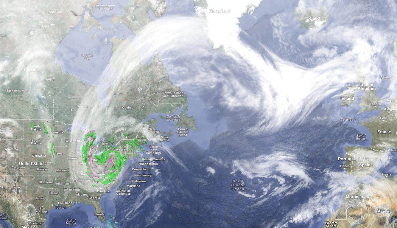
New Nor’easter may hit East Coast next week
Another storm is exactly what the mid-Atlantic and Northeast coast don’t need. But the European Centre Medium Range Forecast (EURO) model is forecasting exactly that this time next week.
The EURO, which sniffed out Sandy 8 days before it hit, shows an area of low pressure developing off the Georgia/South Carolina coast the night of the election (November 6), and then moving up the coast into New England by Wednesday night.
NOAA’s Hydrometeorological Prediction Center
leads its extended forecast discussion with the headline:
...NOR’EASTER POSSIBLE FOR MID-ATLANTIC/NEW ENGLAND STATES BY ELECTION DAY INTO NEXT THURSDAY...
The simulated storm - while much weaker than Sandy - shows moderate rains and gusty (not damaging) winds in the same areas hit so hard earlier this week. It also shows some potential for snow on the interior.
These conditions would obviously hamper clean-up efforts in areas afflicted by Sandy’s coastal flooding and raise the seas again, but to a much lesser degree.
The U.S. GFS model also simulates a storm in that time frame, but it stays far enough out to sea to mostly spare the mid-Atlantic before curving inland in southern New England.
Exact track details and, thus, the localized impacts of the storm are not possible to pin down at this range. But once again, the overall pattern shows the potential for a storm that would bring wind, rain, and inland snow to parts of the mid-Atlantic and/or Northeast.
------------------------------------------SEPARATOR--------------------------------------------------
http://www.accuweather.com/en/weather-news/next-weeks-snowstorm-is-a-big/44753
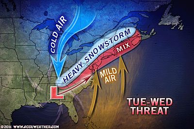
More and more signs are pointing toward a major storm along much of the Atlantic Seaboard next week, meaning a wind-whipped snow for some areas and wind-driven rain for others.
The storm could rank right up there with the Christmas Weekend Blizzard and could hit part of the same area, or different areas farther inland. No matter what, it looks like a "big deal."
While the storm will have its nasty moments over
the Rockies, Plains and part of the Midwest this weekend into early next week, it will be at its worst along the Atlantic Seaboard, where it is forecast to markedly strengthen.
Arctic air building into the Northeast will also be a major factor in the big storm that will unfold.
Storm Track(s)
The key for what the weather will be in your area is the exact track of the storm.
A track along or just inland of the coast would bring rain over the eastern Carolinas and even a wintry mix into the I-95 corridor of the mid-Atlantic. This track would dump heavy snow, perhaps on the order of 1 to 2 feet, over the Appalachians. Snowfall rates would be intense with perhaps 1 to 3 inches per hour.
A track just off the coast would bring the heaviest snow to the I-95 cities and the beaches, as we have seen before, thus sparing the Appalachians the worst.
It is also possible the storm could swing out off the southern Atlantic coast, then hook back in over the Northeast with a more complex precipitation pattern.
No matter which way the storm tracks, it looks like big trouble for the Atlantic Seaboard next week, not only for the U.S., but all the way to Atlantic Canada.
What Will the Storm Bring to Me?
In the worst-case scenario, which may not be that far on the extreme end with this storm, an all-out blizzard may hit some inland areas, while a period of strong onshore winds could lead to coastal flooding.
If some places get heavy rain on top of the thick blanket of snow on the ground, everything from urban flooding to roof collapses could occur.
No matter what the storm brings to various locations along the Atlantic Seaboard next week, it will lead to major travel disruptions, closed schools, blown budgets and perhaps life-threatening conditions.
The storm has the potential to shut down some major highways and ground flights, stranding motorists on the road and airline passengers at airports.
Atmospheric Dynamics
The storm promises to be potent due to plenty of moisture and energy from a lingering large temperature contrast. The excess moisture slamming into the cold sea of air in the Northeast will yield intense precipitation.
A storm rolling southeastward along the Rockies this weekend will dip toward the Gulf of Mexico early next week. As it does, it will grab moisture from the relatively warm waters.
A temperature contrast from northwest to southeast will help provide the energy for a big storm in the East next week. An example of this contrast is the range in temperatures on Friday with a low of minus 46 degrees in northern Minnesota to a high in the lower 80s in South Florida.
Meanwhile, the coldest air of the season so far will be parked over the Northeast, including many subzero low temperatures in northern New England.
It appears the jet stream, which is a river of air high in the atmosphere that guides weather systems along, will bend, allowing the storm to track up along or just offshore of the Atlantic Seaboard during the middle of next week.
Keep Checking Back for Updates
Details on the storm track and how bad the storm will be from location to location will unfold into early next week. Keep checking in at AccuWeather.com for updates and on our network of radio and TV stations around the country.

 out.
out.