http://www.wunderground.com/blog/angelafritz/comment.html?entrynum=30
Maine
•
Storm tide and surge: 1 to 2 feet of storm surge on top of tides.
•
Wind: 30 to 40 mph with gusts up to 60 mph. The strongest winds will occur Monday afternoon and evening.
•
Rain: Widespread totals from 1 to 3 inches, with isolated amounts up to 5 inches
•
Inland Flooding: Significant urban and small stream flooding is possible, which could linger into Tuesday.
•
Power outages: Spotty power outages are possible as wind takes down branches and trees.
Massachusetts
•
Storm tide and surge: Up to 4 feet of storm surge on top of tides, with a 10-20% chance of surge exceeding 5 feet.
Storm tide forecast for Buzzards Bay, MA is 7-8 feet.
Storm tide forecast for Woods Hole, MA is 6-7 feet.
Storm tide forecast for Nantucket, MA is 6-7 feet.
•
Wind: 25 to 35 mph with gusts up to 60 mph. The strongest winds will occur Monday afternoon and evening
•
Rain: Widespread totals from 1.5 to 3 inches, with isolated amounts up to 5 inches
•
Inland Flooding: Significant urban and small stream flooding is possible, which could linger into Tuesday.
•
Power outages: Spotty power outages are possible as wind takes down branches and trees
Rhode Island
•
Storm tide and surge: 4 to 5 feet of surge is possible on top of tides, with a 10-20% chance of surge exceeding 5 feet.
Storm tide forecast for Newport, RI is 8-9 feet.
Storm tide forecast for Providence, RI is 10-11 feet.
Storm tide forecast for Block Island, RI is 7-8 feet.
•
Wind: 25 to 35 mph with gusts up to 60 mph. The strongest winds will occur Monday afternoon and evening
•
Rain: Widespread totals from 1.5 to 3 inches, with isolated amounts up to 5 inches
•
Inland Flooding: Significant urban and small stream flooding is possible, which could linger into Tuesday.
•
Power outages: Spotty power outages are possible as wind takes down branches and trees
Connecticut
•
Storm tide and surge: 6 to 9 feet of surge is possible on top of tides, with a 60% chance of surge exceeding 5 feet west of Bridgeport. Surge will be worse as you move west along the Connecticut coastline.
Storm tide forecast for New London, CT is 8-9 feet.
Storm tide forecast for Bridgeport, CT is 14-15 feet.
•
Wind: 25 to 35 mph with gusts up to 60 mph. The strongest winds will occur Monday afternoon and evening
•
Rain: Widespread totals from 1.5 to 3 inches, with isolated amounts up to 5 inches
•
Inland Flooding: Significant urban and small stream flooding is possible, which could linger into Tuesday.
•
Power outages: Power outages are possible as wind takes down branches and trees
New York
•
Storm tide and surge:
Long Island Sound -- 6-7 feet on top of tide with a 50% chance of exceeding 7 feet. Storm tide forecast for Port Jefferson is 13-14 feet.
Manhattan -- 4-5 feet on top of tide with a 40% chance of exceeding 7 feet.
Staten Island -- 4-5 feet on top of tide with a 60% chance of exceeding 7 feet.
Storm tide forecast for Montauk, NY is 7-8 feet.
Storm tide forecast for Port Jefferson, NY is 13-14 feet.
Storm tide forecast for Kings Point, NY is 12-13 feet.
Storm tide forecast for The Battery, NY is 9-10 feet.
Storm tide forecast for Bergen Pt, NY is 10-11 feet.
•
Wind: Long duration, damaging winds expected. 35 to 45 mph with gusts up to 80 mph. The strongest winds will occur Monday afternoon and night.
•
Rain: Widespread totals from 2 to 4 inches, with isolated amounts up to 6 inches, especially in the higher elevations. 1 to 2 inches PER HOUR are expected where the heaviest rain bands set up.
•
Inland Flooding: Widespread urban flooding is expected Monday and into Tuesday. Fast-responding streams are expected to flood, as well. The flooding will be exacerbated by blockages in storm drains as well as rising storm tide.
•
Power outages: Power outages are possible, even likely, as wind takes down branches and trees.
Pennsylvania
•
Storm tide and surge: 1 to 2 feet of surge is possible on top of tides, with a 30-40% chance of surge exceeding 3 feet.
Storm tide forecast for Philadelphia, PA is 8-9 feet.
•
Wind: 35 to 45 mph with gusts up to 70 mph. The strongest winds will occur Monday afternoon and evening and into Tuesday. Wind speeds will increase closer to the coast.
•
Rain: Widespread totals from 4 to 10 inches, with the highest amounts mainly from Philadelphia metro southward. Heavy rain is expected to begin Sunday night, with the heaviest occurring Monday night into Tuesday.
•
Inland Flooding: Significant urban and small stream flooding is possible, which could linger into Tuesday. RIver flooding is possible.
•
Power outages: Power outages are likely as wind takes down branches and trees.
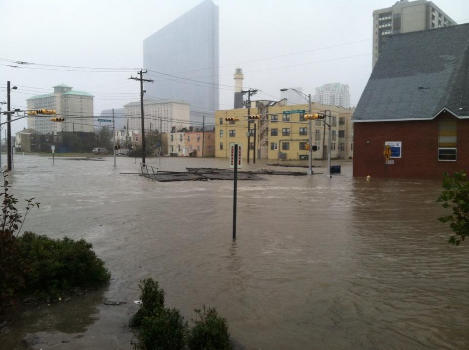
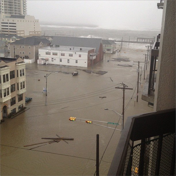
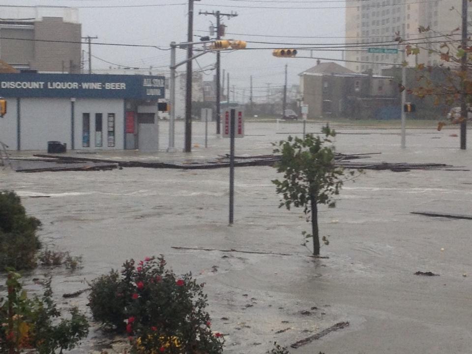
New Jersey
•
Storm tide and surge: 4 to 5 feet of surge is possible on top of tides, with a 30-50% chance of surge exceeding 7 feet. Surge will be worse as you move north along the New Jersey coastline.
Storm tide forecast for Sandy Hook, NJ is 10-11 feet.
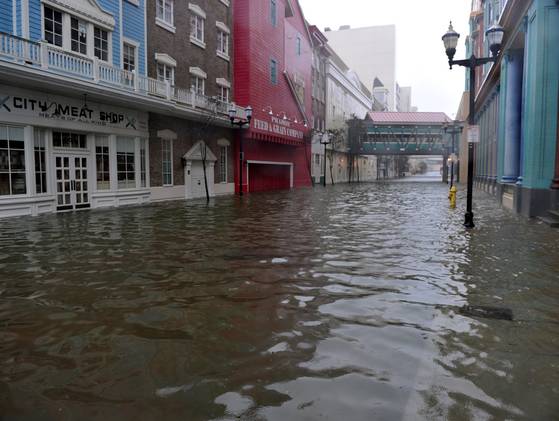
Storm tide forecast for Atlantic City, NJ is 9-10 feet.
Storm tide forecast for Cape May, NJ is 9-10 feet.
•
Wind: 35 to 45 mph with gusts up to 70 mph. The strongest winds will occur Monday afternoon and evening and into Tuesday. Wind speeds will increase closer to the coast.
•
Rain: Widespread totals from 4 to 10 inches. Heavy rain is expected to begin Sunday night, with the heaviest occurring Monday night into Tuesday.
•
Inland Flooding: Significant urban and small stream flooding is possible, which could linger into Tuesday. RIver flooding is possible.
•
Power outages: Power outages are likely as wind takes down branches and trees.
Delaware
•
Storm tide and surge: 4 to 5 feet of surge is possible on top of tides, with a 20% chance of surge exceeding 6 feet.
Storm tide forecast for Reedy Point, DE is 8-9 feet.
Storm tide forecast for Lewes, DE is 9-10 feet.
•
Wind: 35 to 45 mph with gusts up to 70 mph. The strongest winds will occur Monday afternoon and evening and into Tuesday. Wind speeds will increase closer to the coast.
•
Rain: Widespread totals from 4 to 10 inches. Heavy rain is expected to begin Sunday night, with the heaviest occurring Monday night into Tuesday.
•
Inland Flooding: Significant urban and small stream flooding is possible, which could linger into Tuesday. RIver flooding is possible.
•
Power outages: Power outages are likely as wind takes down branches and trees.
Maryland and Washington D.C.
•
Storm tide and surge: 4 to 5 feet of surge is possible on top of tides on the ocean coast, with a 10-20% chance of surge exceeding 6 feet.
•
Wind: 35 to 45 mph with gusts up to 60 mph. The strongest winds will occur Monday afternoon and evening and into Tuesday. Wind speeds will increase closer to the coast, and will also be stronger along the ridges.
•
Rain: Widespread totals from 3 to 6 inches, with locally higher amounts, especially in the D.C. metro. Heavy rain is expected to begin Sunday night, with the heaviest occurring Monday night into Tuesday.
•
Inland Flooding: Moderate to major flooding is possible on the smaller creeks and streams. Flooding is also possible on the larger mainstream rivers beyond Tuesday.
•
Power outages: Power outages are likely as wind takes down branches and trees.
Virginia
•
Storm tide and surge: 2 to 4 feet of surge is possible on top of tides on the ocean coast.
Storm tide forecast for Chesapeake Bay Bridge Tunnel, VA is 6-7 feet.
Storm tide forecast for Wachapreague, VA is 7-8 feet.
Storm tide forecast for Kiptopeke Beach, VA is 6-7 feet.
•
Wind: 35 to 45 mph with gusts up to 60 mph. The strongest winds will occur Monday afternoon and evening and into Tuesday. Wind speeds will increase closer to the coast, and will also be stronger along the ridges.
•
Rain: Widespread totals from 3 to 6 inches, with locally higher amounts, especially in the D.C. metro. Heavy rain is expected to begin Sunday night, with the heaviest occurring Monday night into Tuesday.
•
Inland Flooding: Moderate to major flooding is possible on the smaller creeks and streams. Flooding is also possible on the larger mainstream rivers beyond Tuesday.
•
Power outages: Power outages are likely as wind takes down branches and trees.
North Carolina
•
Storm tide and surge: 2 to 4 feet of surge is possible on top of tides.
Storm tide forecast for Duck Pier, NC is 7-8 feet.
•
Wind: 35 to 45 mph with gusts up to 60 mph. The strongest winds will occur Monday afternoon and evening and into Tuesday. Wind speeds will increase closer to the coast, and will also be stronger along the ridges.
•
Rain: An additional 1 to 3 inches possible overnight Sunday.
•
Inland Flooding: Flood threat is tapering off as Sandy moves north.
•
Power outages: Sporadic power outages are possible as wind breaks branches off trees.

 )
)

 ing Albany, and she doesn't leave her apartment, I cannot stress enough to her how little she has to worry about. I really wish she would stop letting news channel hyperbole get her so worked up.
 ( such a shitty feeling...